
Henrietta ZIP Code Coverage
Official Henrietta records support three ordinary postal labels as Henrietta-related: 14467, 14586, and 14623. The same records also show several edge labels, but they do not establish a complete townwide ZIP boundary set. Postal-city names are not legal-municipality names. The table preserves the conservative distinction between the three verified Henrietta-related labels and examples that still need an address-specific parcel and USPS check.
| ZIP | Areas Covered | Post Office | Notes |
|---|---|---|---|
| 14467 | Core, southern, and western Henrietta examples | Henrietta postal label; station name not verified | Town PO Box and official project, cemetery, and historic examples |
| 14586 | Western and southern Henrietta examples | West Henrietta postal label; station name not verified | Official project, cemetery, and historic examples; postal label does not change the legal town |
| 14623 | Northern, eastern, and central Henrietta examples | Rochester postal label; station name not verified | Town Hall and Calkins, East Henrietta, and RIT-area examples |
| 14534 | Edge mailing example | Pittsford postal label | Tinker Homestead example; parcel confirmation required |
| 14543 / 14618 | Edge mailing examples | Rush / Rochester postal labels | Official edge records located; USPS and parcel confirmation required |
No formal local post-office station names, ZIP splits, or historic realignments were found in the reviewed sources. The table uses postal labels shown on official records, not an unsupported claim of delivery coverage for every parcel.
Henrietta Postal Labels, Not Town Lines
Henrietta is one legal town, yet official records use multiple postal city labels. Town Hall uses Rochester 14623. The Town’s PO Box uses Henrietta 14467. Western and southern roads and cemetery records can use West Henrietta 14586. Those labels are useful search variants, but none independently answers whether an address is inside the Town of Henrietta.
The practical sequence is three-part normalization: preserve the house number and street exactly, retain the postal city and ZIP, then verify the legal municipality. The County GIS supplies ZIP boundaries alongside Towns/Villages boundaries and parcel geometry. A ZIP polygon remains mailing geography, so the municipality/SWIS field and parcel ID should travel with the result.
Henrietta ZIP Code Boundary Checks
The county’s ZIP boundary legend is the local geographic layer. It includes 14467, 14586, and 14623 among Monroe County ZIPs. Use it to see the map relationship, then test a particular delivery address with USPS and check the parcel’s municipality/SWIS. Do not substitute a ZIP centroid or a map label for legal parcel evidence.
For an address that appears on an older map or directory, retain both the historical string and the current standardized string. The County Parcel Viewer has Address Search, TaxIDSearch, parcel polygons, ZIP boundaries, and municipal boundaries. Its assessment joins are maintained daily, the parcel layer is recreated weekly, and distribution is quarterly, so record the query date and the roll date too.
The county ZIP legend is illustrated in the official source image below.
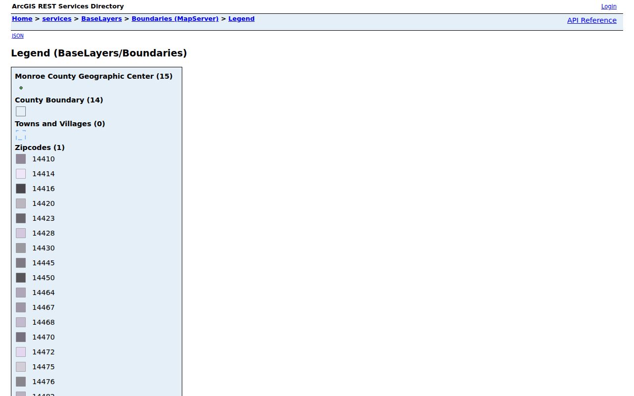
The legend supports a geographic cross-check, while USPS remains the authority for a postal city and ZIP combination at one address.
Henrietta ZIP Code Search Fields
The Monroe County voter form accepts a ZIP field, but it is a person-specific lookup rather than a ZIP-wide name list. Use it only to check an individual’s registration-related result with the full identifying inputs the form requests. The research did not find a public Monroe County screen for exporting every name in a ZIP. Registration status is not a current-location finding, and the live screen may not show the event history behind a status.
| Field | Observed form behavior |
|---|---|
| Street # | House-number field for the address query. |
| Street Name | Autocomplete: begin typing and choose the offered street. |
| ZIP | Postal filter used with the other person-specific fields. |
| Last Name | Individual name field, not a bulk directory filter. |
| DOB | Date of birth entered as MM/DD/YYYY for person-specific verification. |
County results are described as registration information, polling place, sample ballot, absentee or mail-ballot status, and elected-official context. They are not a downloadable Henrietta residents list. For an official voter-file request, New York requires an elections purpose and Board supervision.
Henrietta ZIP Code Search Steps
A ZIP can narrow a record search, but the search mode must be stated. USPS validates one delivery address. GIS displays a ZIP polygon and parcel context. The county property result provides address and municipality/SWIS fields but no confirmed public ZIP-wide resident export. The voter form accepts ZIP as an individual filter. Each route answers a different question.
- Keep the raw house number, street suffix, postal city, and ZIP together before altering any part of the string.
- Use the USPS ZIP Code Lookup for the specific delivery address and retain any standardized suggestion.
- Check the county ZIP polygon, parcel ID, and municipality/SWIS in the Parcel Viewer.
- Use a roll, voter, or directory search only in the mode that source actually supports, with its date and source role attached.
- Once the ZIP is narrowed to a street, use the Henrietta street address directory for the address-level record trail.
Note: A result should name its query mode, such as USPS validation, parcel-map browse, individual voter lookup, or a historical directory section.
Henrietta Postal and Parcel Fields
The County Real Property Portal is designed around parcel and assessment information. Its inspected result format includes street address, municipality/SWIS, parcel ID, final-roll date, assessed values, property class, lot details, map links, and sale history. The research inspection received a 403 response at the live search landing, so those field labels are a format inventory rather than a current Henrietta result. Use the official property gateway and a county office or public-terminal fallback when the screen is unavailable.
A tax mailing address and a situs address mean different things. The situs is the physical parcel address; the tax mailing line is where assessment mail is sent. A postal city in either field should not be converted into a municipal conclusion. Record the roll date, parcel ID, and municipality/SWIS alongside any address result.
- ZIP code
- A postal routing code. It is not a legal town boundary.
- ZIP+4
- An added delivery-detail code that USPS may return for a specific standardized address.
- PO Box ZIP
- A postal code used for a box address. It does not identify a parcel location.
- Unique ZIP
- A ZIP assigned to one organization or destination. No Henrietta assignment of this type was confirmed in the reviewed sources.
- Carrier route
- A delivery-route grouping. It is not a municipal-boundary label or a residents list.
Henrietta ZIP Code Edge Examples
Three official examples show why a postal label needs context. Town Hall uses a Rochester 14623 address, while the Town’s PO Box uses Henrietta 14467. The Town Historian’s Tinker Homestead address uses Pittsford 14534. All three can relate to Henrietta records, yet they do not establish identical postal coverage or the same municipal conclusion.
Other reviewed town pages contain Rush 14543 and Rochester 14618 edge examples. Treat those as discovery leads only. The research did not capture a USPS-validated set for every Henrietta boundary address, so confirm each with USPS and the parcel municipality before labeling it a Henrietta ZIP result. The same caution applies to an RIT-area postal line: campus geography does not identify a private person’s location.
Note: Keep postal city, ZIP, legal municipality, parcel ID, and source date in separate fields instead of merging them into one location label.
Henrietta ZIP Map Timing
Map and roll dates matter because the county parcel feature layer is maintained on more than one schedule. Assessment joins are updated daily, the parcel layer is recreated weekly, and distribution is quarterly. A viewer result and a roll can therefore be out of step without either source being fabricated. Save the map URL or print/report output with a retrieval date when comparing an address across time.
The Town’s planning maps offer zoning, sanitary, drainage, water, lighting, agricultural, and neighborhood-code layers. They can add area context, but a neighborhood code is not a ZIP, census block, or household record. For historical strings, use the bridge sequence of old address, plat or map or deed, current GIS parcel, then USPS validation.
Henrietta ZIP Code Limits
The ZIP code directory is deliberately conservative. No official Henrietta grid system, annexation conversion table, townwide street-renaming schedule, complete USPS boundary result set, or historic ZIP change was located. Rochester’s 1884–85 renumbering is a neighboring-city research issue, not a rule to apply to Henrietta streets without a confirming town record.
The Henrietta assessor page publishes a 2026 tentative roll plus 2025 and 2024 final-roll links, neighborhood maps, and streets within neighborhood codes. Those dated materials can help anchor a parcel inquiry, but a neighborhood code is planning geography, not a ZIP-wide name filter. Keep the roll year with any assessment field and compare it with the map retrieval date.
When a search returns nothing, test the postal city, street suffix, former address string, parcel municipality, and the collection’s date and geography before concluding that no record exists. Historical Rochester city directories, regional directories, parcel data, and individual voter verification each have different coverage and limits. State the source role and retrieval date rather than treating one ZIP search as a complete answer.